1.Introduction
This manual is for organizers of a rally. It explains the necessary steps to create and manage a rally in the portal.
2.How a rally works
A normal rally which an organizer has planned, has a fixed starting location and a fixed starting time. After driving the rally competitors will finish at a fixed location.
The rally process for the competitor has the following steps.
The competitors sign up for the rally with the organizer.
Before the start of the rally competitors receive the Regulations and knows where and when the start is located.
On the (starting) day of the rally, the rally is visible in the Rallycheck app.
The competitors receive a road book and are started by the organisation.
After driving the rally, competitors receive an email message consisting of:
- an overview of their own control card.
- an (optional) link to an explanation document if the organizer chooses to do so
- a link to an overview of the route the competitor has driven, including all encountered and saved passage and time controls.
The organisation of the rally receives an email per competitor with the control card of the finished competitor
The rally organizer of the rally calculates the results using their own system or uses one of the results systems supported by Rallycheck.
At the conclusion of the rally, the organisation publishes the results.
3.Materials
when creating a rally in the Rallycheck portal you will need the following information.
- List of participants
- The passage and time controls
- A digital rally sign
- A digital logo for use in the Rallycheck app
- An explanation document (optional) to send to the competitors after completing the rally
the organizer of the rally is responsible for this information. All the information can be uploaded and configured in the Rallycheck portal.
4.Participants
The participants list is used to connect rally competitors to the Rallycheck app account.
The following information is used to identify participants:
- Rally class
- Starting number
- Driver information
- Navigator information
- Car information
- Rallycheck email address
An Excel template can be downloaded from the Rallycheck portal. Use this template to fill in all the competitors information. You can upload the Excel sheet with competitors to the portal. During the import of the competitor information, Rallycheck will attempt to reconcile the competitors to Rallycheck accounts
5.Best practices for the organiser
Placing digital route controls is easy to do, but does have a learning curve. The correct positioning of physical passage and time control is also something that is important. After doing this often, a rally organizer acquires knowledge and skill in placing these controls correctly.
The positioning of digital controls on a route also requires some experience to get it right.
In the following paragraphs we list some best practices for organizers that have just started using Rallycheck.
5.1.The START control
- Place the START control at some distance from the actual start.
This may sound strange, but it is important. When the Rallycheck app is active, controls are shown on screen when you are within the proximity of the control. If the start control is at the actual START location, there is a chance that competitors will save the start multiple times. - Make the START control neutral for the results
This is a good thing to do, just in case some competitors drive through the start multiple times. - Make sure the START control is not on a route to get to the rally
If the START control is on a major road on the way to the beginning of the rally, then competitors that have activated the app, will encounter the START control. This may not be desirable. - Show the position of the START control clearly in the road book
This is advisable because competitors will know the position of the first (START) control. When passing the control and seeing it on the screen of the app, they will know everything is working correctly.
5.2.The FINISH control
- Place the FINISH control at some distance from the actual Finish of the rally
We advise this in order to make sure that competitors do not cross the FINISH control multiple times - Make the FINISH control neutral for results
If a competitor does pass the finish multiple times, that will not effect the results - Make sure that competitors do not pass the FINISH control of a previous or future stage!
When driving a rally with multiple stages there will be multiple START and FINISH controls. It is important that competitors do not pass START and FINISH controls in the wrong order. This confuses the system. Rallycheck has been configured to always show controls that you pass, it is the organizers responsibility to make sure that START ad FINISH controls are passed in the intended order. - Show the position of the FINISH control clearly in the road book
This is advisable so competitors know when en where the last control is placed - Place the FINISH control so that it can not be missed
Make sure that all competitors pass the FINISH control. A FINISH control is necessary for the Rallycheck system to determine that a competitor has finished a stage. If a FINISH is not passed, the rally will remain active in the Rallycheck app.
5.3.Positioning a route control
The correct positioning of a route control on the digital map is important. Here are some best practices.
- Do not place controls at a stop light
At a stop light, competitors may be stationary for some time. If a control is placed here, it is possible to detect the control a number of times. - Use our default proximity of 45 meters to a control as much as possible
This is a tested and proven value. When using the default value, you will never miss a control - Position a control in the middle of the road
An organizer is used to placing a control at the side of a road. That is not necessary. Just place the control on the middle of the road. - Position the control next to the road in extreme or cramped situations
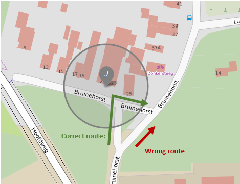
In some cases it may be necessary to position the control next to the road. If at all possible, use our default proximity of 45 meters. Part of the proximity of the control will be on the correct route. Correct positioning of the control will ensure that competitors do not detect the control when driving the wrong route.

- Do not use a small proximity
We have done a large number of tests with different proximity’s around a control position. Generally speaking the larger the proximity, the better. Small proximity’s in the order of 5 or 10 meters will result in problems. You may check the route, and everything seems OK. But when 100 competitors pass the position during the actual rally, using all types of phones, you will see that the control is not detected by 100% of the competitors. We advise organizers not to use a proximity of less than 20 meters, preferably more! - Speed is a factor
Using our default proximity of 45 meters, a competitor will have to drive faster than 324 km/h in order to miss a control due to the speed of the vehicle. When using a proximity of 20 meters a control can be missed at a speed above 144 km/h.
5.4.Detecting the exact position
When using the Rallycheck GPS system we are always asked how accurate the position of a competitor can be determined. In other words can the correct route of the competitor be determined to a few meters. the answer is YES, if use use the system correctly!
What is possible:
- Distance
We advise a distance of about 10 ~15 meters between the correct route and the wrong route of a competitor. With this distance it should always be possible to determine the difference of the followed route. - Check the route, not the position
Often, controls are placed en route in a difficult position, just to make sure the competitor has passed the control. With Rallycheck we advise organizers to position controls so as to check the route that has been driven. This requires a slightly different approach, but many difficult situations can be resolved when taking this into account. - Check the bearing of a competitor
In the Rallycheck app, it is be possible to check the bearing of the competitor. So a route control can be correct when driving from north to south. When driving in the wrong direction (for example from south to north) the control will not be shown on screen. The enables an organizers to use this extra possibility to determine if the competitor has followed the correct route.
What is not possible:
- The lamp post
Placing a control on the back of a lamp post in order to determine the correct route is not possible in Rallycheck. A difference in the followed route of 1 to 2 meters is just asking too much of the current technology. This will work correctly for about 70% of the competitors. That is way too little for use in a rally. - The parallel road
When two roads are exactly adjacent and parallel, it is difficult to determine on which of the two roads the competitor is driving. When encountering this situation, try to find a part of the route where these two roads are as far apart as possible. Try positioning a control where the two roads are more than 10 meters apart.
Background:
When using a GPS position system you have a pretty good accuracy. There are however, a number of things that can influence the accuracy. We have listed some of these effects below. This way we hope the organizer of a rally will better understand the technology we use and better understand the possibilities (and limitations) of our Rallycheck GPS system.
- Difference in phones
Not all phones are created equal! When designing Rallycheck we decided that it would be best used when a competitor can use their own phone. This has dramatically increased the accessibility of Rallycheck for all users and rally enthusiasts! A drawback is that while some phones have a very accurate GPS system, other phones do not. As an organizer, you will have to take in account that some competitors have less accurate phones than others. We do expect the GPS accuracy of phones to improve further in the following years. - Inaccuracy while driving
The accuracy of a GPS location service is not constant. It is influenced by a number of external factors. These can be atmospheric conditions, mountains, trees, tunnels etc. During the rally a phone can have an accuracy of 3 meters but this can fluctuate and increase to 10 / 20 meters accuracy in some places. The accuracy during the rally can not be determined beforehand. We do however show the inaccuracy of the GPS system on the screen of the Rallycheck app. The competitor can see this information on screen. We also log this information so that a competitor can determine the average inaccuracy of the phone during the rally. - Inaccuracy of the digital road map
A road map is an interpretation of the real world, no more no less. This is also true of a digital road map! Even though you can zoom into the most precise location on the map, how sure can you be that the road on the map will correspond exactly to the real situation. is it not possible that there is a difference of 1 cm? or 1 meter, or 5 meters? We can of course never be sure that each and every position of the digital map corresponds exactly to the actual situation! - Speed
Location services on a smartphone is limited to one measurement per second. The consequence is that, the faster you drive, the larger the distance between two measurements of a position. When driving 36 km/h, you cover a distance of 10 meters per second. So when encountering a route control using GPS, you will on average encounter the control with a tolerance of 5 meters in the driving direction. You will also encounter the control with an average tolerance of half a second. Because a phone measures the location once a second, you will always have a fault tolerance of half a second. The exact position of the location of a competitor is dependent on the speed at the time of measurement. - Standing still
Location services has the tendency to “bounce around” when standing still. So every second there is a slightly different measurement of the position of the competitor. These slightly different measurements result in a sort of “blot” of the position of the competitor, when standing still for an amount of time. When standing still exactly on the boundry of a route control, you may encounter strange effects. - Geo-fencing
Rallycheck uses geo-fencing for calculating the position of a competitor. “A geo-fence is a virtual perimeter for a real-world geographic area”. That means that every control point on the road map consists of an exact location combined with a proximity radius within which the route control can be detected. The geo-fence combined with the competitors speed and the current inaccuracy of the GPS signal of the phone determines if the route control is detected or missed.
6.Placing route controls in the app
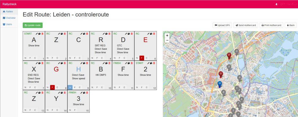
The route controls are composed by the organizer of the rally. The list of route controls is called the “Mother Card”
You can compose the mother card in the Rallycheck portal. This is the easiest way to make the mother card. We have developed a tool which enables you to simply position controls on a road map. You can add all the relevant information to the route control using the portal. When doing this, you create the entire mother card with all the way points (route controls).
When a competitor selects a rally in the Rallycheck app, the way points that have been created are downloaded to the smartphone.
6.1.Rallycheck portal
With the Rallycheck portal an organizer can position all route controls on rhe road map.
The Rallycheck portal is available via https://my.rallycheck.com
You can login using the same username and password combination as with the Rallycheck app. Login is however only available to organizers of a rally. Contact us if you need access to the portal. The Rallycheck portal is being actively developed and the functions and tools within the portal are continuously being enhanced. Our goal is to create a complete environment for the organisation of rallies.
Using the portal you can insert passage controls and time controls online. Just click on the road map to position a control and enter the relevant information.
On the right side of the screen, you see the road map with the controls. The left side of the screen is the mother card with the relevant extra information per control.

6.2.Check your route
We believe that it’s very important that competitors have a positive experience using the Rallycheck app with a rally. Part of that experience is detecting the route controls during the rally. It is extremely important that you check the route by actually driving the route using the Rallycheck app in order to experience first hand if everything is working correctly.
By checking the route you will be able to confirm that all controls are positioned in the correct place and are able to be detected by the app. When finishing the check of the route and passing the FINISH control, you will also receive the email with an overview of the control card and the route you have just driven. This will help you evaluate if all controls are placed correctly.
Based on your evaluation of the route you can change or improve certain aspects of the positioning of route controls.
7.Digital rally sign
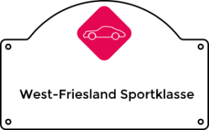
After completing the rally a competitor receives an email message with an overview of their control card. Basically all the controls that are also seen on the smartphone. At the top of the email there is room to place your rally’s rally sign.
The digital rally sign has the following dimensions: 320 x 199 pixels.
The digital rally sign is a .png file. See the following example.

An organizer can upload the digital rally sign in the portal on the “Edit Rally” page.
8.Digital logo
In the Rallycheck app a competitor can select a rally. The app shows the name of the rally preceded by a logo of the rally.
The logo has the following format: 140 x 140 pixels.
The digital logo is a .jpg file. See the following example.

Although the logo is square, it will show as a round logo in the Rallycheck app. Please postion the logo in such a manner that loss of the information in the corners is expected.
The logo can be uploaded in the Rallycheck portal on the “Edit Rally” page.
9.Explanation document
After completing the rally a competitor will receive a link tot a personalized explanation document. This is a PDF document. The document has the following sections:
- Front page
- One or more pages of road map information with the rally route explained and the controls placed on the card
- An explanation of the controls
- The mother card with all the controls
Sending the link to the explanation document is of course optional. We do advise all rally organisations to do this as it enhances the rally experience for your competitors!


